
Ecoregions Surrounding Central Catholic High School
- Admin
- Feb 13
- 4 min read
James Bendele, Ministry Lead for Marianist Encounters at Central Catholic High School, San Antonio, TX, sends us this informative article.
Central Catholic High School can be found on the northern boundary of downtown San Antonio. The San Antonio Zoo, Brackenridge Park, the San Antonio Botanical Gardens, and the University of the Incarnate Word are found within walking distance of Central Catholic. In fact, the headwaters for the San Antonio River can be found on the campus of the University of the Incarnate Word. Along rivers (and most riparian habitats) in south Texas, one can expect to find sycamores, pecan trees, bald cypresses, and black willows. One environmental concern is that the San Antonio River has been “invaded” by Asian clams in recent years.

Central Catholic sits on the transition zone between two distinct ecological regions – the Blackland Prairies to the immediate east and the South Texas Brush Country to the immediate south. The Blackland Prairies are the southeastern extension of the American Great Plains. At one time, this was historically grassland. Over the past two centuries, however, most of it has been converted into land for agriculture. In its prime, the Blackland Prairies would have been home to millions of bison!

The South Texas Brush Country extends deep into adjacent Mexico. The last of Texas’ ocelots can be found in this region! It is characterized by mesquite and many other thorny species of shrubs and small trees. Furthermore, this region is home to many species of tropical birds (such as green jays and great kiskadees) whose northernmost range extends into this region of deep south Texas.


Approximately 15 miles to the north of Central Catholic, the Edward’s Plateau (oftentimes referred to as the “Hill Country”) becomes the dominant geological and biological region. The Edward’s Plateau is characterized by rolling limestone hills with thin soil, as well as live oak and juniper woodlands. It is also where the endangered golden-cheeked warbler can be found!


Views from Government Canyon State Natural Area (Middle) and Enchanted Rock (Right)
If one continued east in a line from Floresville to Seguin, the southernmost tip of the Post Oak Savanna could be observed. This ecoregion extends northeast until it reaches the Ozarks of Missouri. Palmetto State Park (which “allegedly” has had Bigfoot sightings in recent years) is found in this region.

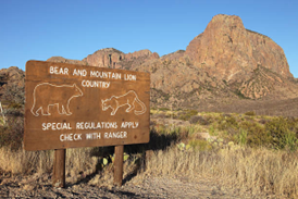
Moreover, approximately 150 to the west, the Trans-Pecos ecoregion emerges. The Trans-Pecos is the eastern tip of the Chihuahuan Desert. Big Bend National Park, as well as the highest peaks in Texas, are found here. It is one of the few places in Texas (and in North America, for that matter), where elk, javelina, pronghorn, bighorn sheep, mountain lions, and black bears can all be spotted with regularity! It is also one of the best places in all of America to look at Native American cave paintings. In addition, the famous McDonald Observatory is located in this region (in the Davis Mountains). This is due to the clear desert skies. Interestingly, the rivers with the most clarity are also said to be found in this region. In fact, the Devil’s River (west of Del Rio) is said to be the “cleanest” river in all of Texas! (Rivers in southern and eastern Texas typically display more turbidity.) Up in the mountains of west Texas, Ponderosa Pines (yes, the same species found in the Rockies) can be observed, as well!


Lastly, it’s only 160 miles from Central Catholic to the Texas Coast! It’s also just a little more than 200 miles to the grasslands of the Texas Panhandle. In conclusion, Central Catholic is in a unique ecological hotspot. Plains transition to our east. A unique blend of brush and semitropical diversity can be found to the south. The scenic Hill Country is just to our north, while deserts and mountains lie just beyond the reaches of the Hill Country.


When the Marianists founded Central Catholic and St. Mary’s in 1852, it would have been possible to observe jaguars, mountain lions, black bears, American alligators, bison, and possibly even elk all overlapping in this one region. Obviously, a lot has changed since then, but this region of Texas is still home to some of the best state parks in all of America. After all, if one was inclined to do some camping, hiking, or wildlife viewing, it’s a relatively short drive from Central Catholic to Garner State Park, Lost Maples, Enchanted Rock, Palmetto State Park, or even Bastrop State Park (many of our students who go to A&M for college will have to drive right by Bastrop State Park on their way to College Station).

One last thought…if one was more into fishing, it’s hard to beat Choke Canyon State Park to the south or Guadalupe River State Park to the north. Both are less than an hour’s drive from Central Catholic!


Alligator gar caught at Choke Canyon (left); Rainbow trout caught on the Guadalupe (right).

Here are some links to explore further including some sources for the images:

Comments